

The short answer
Moderately accurate for storms, weak for addresses. Most hail maps are radar-derived estimates of hail size aloft over a grid cell, sometimes blended with sparse human storm reports. They are useful for narrowing down a storm date and confirming a storm produced hail nearby. They cannot prove your vehicle was damaged, and a clean map over your address does not prove it was not. Start with the vehicle, then corroborate the date.
 Written by the DentPicks Editorial Team
Technically reviewed by Vytas Kucinskas, Founder & Master PDR Technician
Written by the DentPicks Editorial Team
Technically reviewed by Vytas Kucinskas, Founder & Master PDR Technician
Published: Aug 19, 2026 · Last reviewed: Aug 19, 2026 · 9 min read
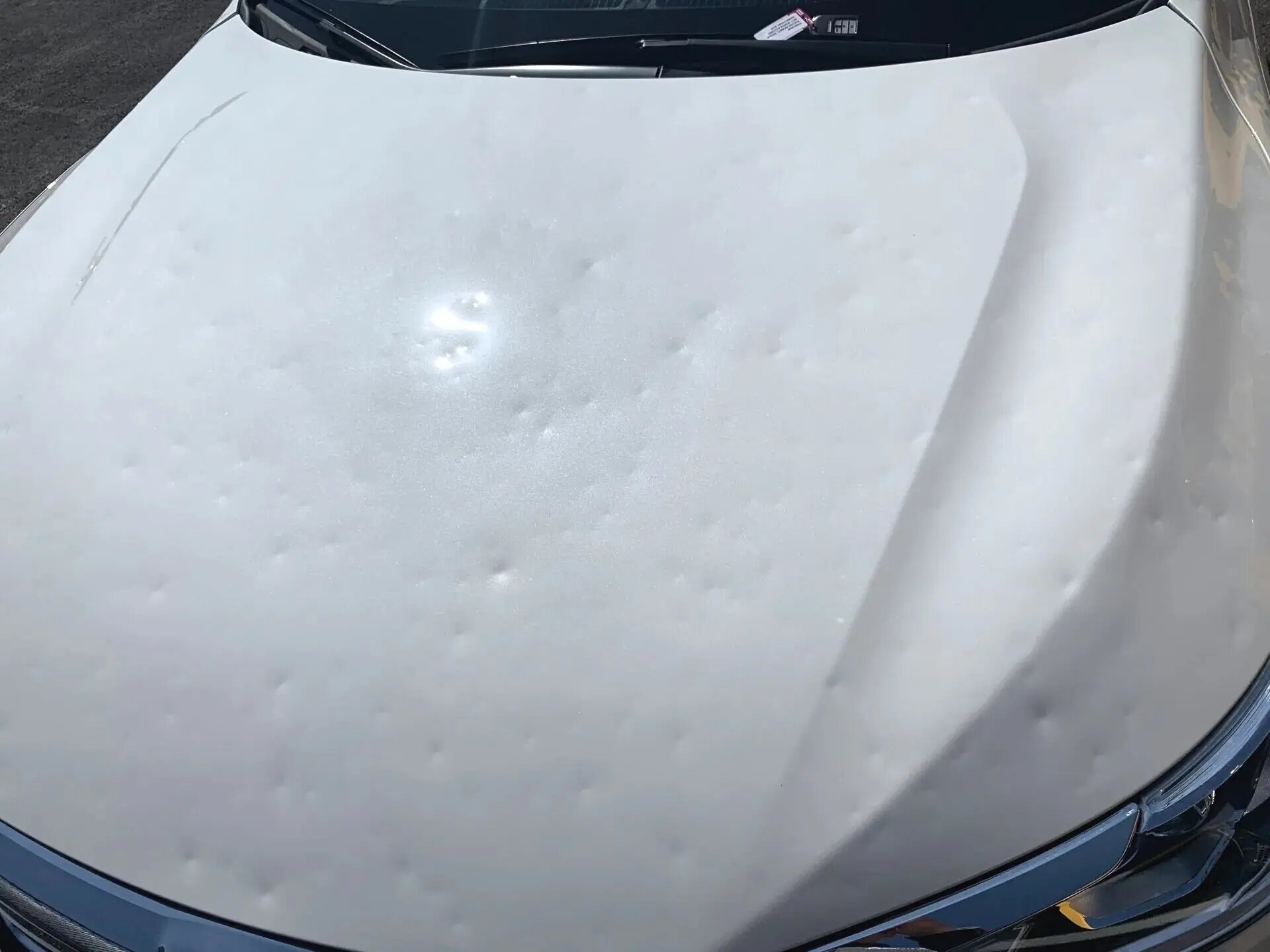
Type your zip code into a hail map and you get a colored swath, a date and a hail size. It looks authoritative — like a measurement of what fell on your street. It is not. It is a model output, and understanding what kind of model it is changes how much weight you should put on it when you are opening a claim.
The short version: hail maps are good at telling you roughly when and where a storm produced hail, and much weaker at telling you what happened at one specific address. They are corroborating evidence, not proof. The proof is the vehicle.
Where the data on a hail map actually comes from
Almost every consumer hail map is built from one of two ingredients, usually blended.
Radar-derived hail estimates. Weather radar does not see hailstones. It sees reflected energy from precipitation aloft, and algorithms infer hail size from that signal — how strong the return is, how high it extends above the freezing level, and how the storm is organized. The common output is an estimate of maximum hail size somewhere within a radar grid cell, at altitude, during a scan window. It is a genuinely useful product, and it is an inference about the storm, not a measurement at your parking spot.
Human storm reports. The NOAA Storm Prediction Center collects reports of hail from spotters, emergency managers and the public, logged with a time, a location and an estimated size. These are real observations of real hail. They are also sparse and uneven: hail gets reported where people are awake, outside, and inclined to call it in. A storm crossing open land at 2 a.m. generates almost no reports regardless of what it dropped.
The five limits worth knowing
- Resolution. Radar data is gridded. A single cell can cover a large area, and the value assigned to it reflects the strongest signal in that cell — not a uniform condition across every driveway inside it.
- Aloft versus ground. Estimates describe hail detected in the storm's upper structure. Stones melt, break up or get carried sideways on the way down. What reaches pavement can be smaller, or can miss entirely.
- Hail is extremely local. Hail cores are narrow and they move. Streets a few blocks apart routinely see very different outcomes from the same storm. A map boundary is a smoothed edge drawn over something that was ragged.
- Wind changes everything for vehicles. Damage depends on stone size, density, fall angle and wind — and on how your car was parked. A carport that shelters a roof from vertical hail does nothing against hail driven sideways at 60 mph.
- Reporting bias. A blank area on a report map often means nobody reported, not that nothing fell.
There is also a distinction people miss entirely: a map showing hail near you and a map showing hail at you are separated by exactly the uncertainty described above. Both look identical on a screen.
How the common sources compare
| Source | What it really is | Best used for | Main weakness |
|---|---|---|---|
| Consumer hail map sites | Radar-derived estimates, often blended with reports | Narrowing down candidate storm dates | Presents modeled output as if it were a measurement |
| NOAA Storm Prediction Center reports | Logged human observations with time, place and size | Confirming a storm produced hail in your area | Sparse and uneven; absence proves nothing |
| National Weather Service local office | Warnings, event summaries and post-storm write-ups | Establishing that a warned hail event crossed your area | Written at county and storm scale, not street scale |
| Insurer's hail verification vendor | A commercial model, usually radar-based | What your carrier is often looking at | Same physical limits as any radar product |
| Your own photos and the vehicle itself | Direct evidence of damage | Proving damage exists and what it looks like | Does not by itself establish a date |
What a hail map can and cannot do for a claim
A map is good at supporting a date. If you know a storm came through and you are not sure whether it was the 12th or the 19th, cross-referencing radar-derived swaths with SPC reports and your local National Weather Service office's event summaries usually resolves it.
A map cannot establish that your specific vehicle was damaged. That comes from inspecting the vehicle. Adjusters and technicians read hail damage by its own signature — the distribution across horizontal panels, the directional pattern from wind, the way dent size clusters, and the absence of the mixed depths and locations you get from years of parking-lot dings. That reading is what separates storm damage from accumulated wear, and it is covered in more detail in our guide on what happens at a hail damage adjuster inspection.
Where maps sometimes work against people is the reverse case: a carrier's vendor data shows little or no hail at your address, and the claim gets questioned. That is not the end of the conversation. Vendor models carry every limitation listed above, and a documented ground-level reality — photographs, damage on the vehicle, a neighbor's repaired car, a roofing job on your building from the same week — is evidence a model cannot override on its own. The Texas Department of Insurance publishes consumer guidance on how to work through a disputed auto claim.
Building a date you can defend
- Photograph the vehicle now, panel by panel at a low angle in daylight, plus the odometer and VIN plate. Our guide on what to do after hail damage covers the full photo set.
- Write down what you remember. Where the car was parked, roughly what time, whether you heard it, whether anything else on the property was damaged.
- Check candidate dates against public sources — SPC storm reports and your local NWS office's event pages — rather than a single commercial map.
- Collect local corroboration. Neighbors with repairs, roofing work in the complex, a text message from that evening, a photo of hail on the ground. Ordinary evidence carries real weight.
- Have the damage read under proper lighting before you decide anything. Ambient light hides a large share of hail dents, which is why panels get read under LED reflection boards at our shop rather than in a parking lot.
- Report promptly. Texas policies generally require prompt notice, and the practical deadlines are covered in our guide on how long you have to file a hail claim in Texas.
How hail maps get used against you
After a significant DFW storm, temporary crews canvass neighborhoods with a hail map on a tablet as the opening move. The map is real; the pitch built on it often is not. Two patterns are worth recognizing.
- "The map shows your street was hit, so you definitely have damage." The map shows a modeled estimate over a grid cell. Whether your car has damage is answerable in ten minutes under proper light, and it is answerable for free.
- "We'll write it up for the storm on this date." Filing on a date that does not match the damage is a problem you inherit, not one the crew inherits. The behavior patterns are laid out in our guide on storm-chaser hail repair operations.
The same logic applies in reverse when someone tells you not to bother filing because a map looks clean over your address. Get the car looked at.
North Texas makes this harder than average
DFW sits in a corridor that produces multiple hail-capable storms in a typical spring, often within weeks of each other. Two consequences follow. First, several plausible dates may exist for the same vehicle, which makes matching damage to a date more than a formality. Second, overlapping events genuinely complicate claims when damage from two storms sits on the same panels. Both are reasons to document early rather than wait out the season — our DFW hail season guide covers the local pattern.
What to do next
Treat the map as a supporting document and the vehicle as the primary one. Photograph the car, identify the storm date that fits, corroborate it against public storm data, and get the panels read under proper lighting before you commit to a claim or to paying out of pocket.
At DentPicks we inspect hail damage free of charge under PDR lighting and will tell you honestly what we see, including when we do not think the damage is worth filing on. You file the claim; we walk alongside you through photos, the adjuster meeting, supplements and paperwork. See how the process runs at our Plano hail repair shop.
Frequently asked questions
My insurer says their hail data shows nothing at my address. What now?
Vendor hail data is a radar-based model with the same limits as any other: grid resolution, estimates made aloft rather than at ground level, and hail cores narrow enough to miss a street. Provide ground-level evidence — dated photos, the damage pattern on the vehicle, roofing work nearby, a technician's inspection — and ask how the determination was made. The Texas Department of Insurance publishes guidance on disputed auto claims.
Can a hail map prove my car was damaged on a specific date?
No. A map can support a date by showing a hail-producing storm crossed your area. Whether your vehicle was damaged, and by that storm, is established by inspecting the vehicle — hail has a recognizable signature in how dents distribute across horizontal panels and in their directional pattern.
Why do neighbors on the same street have different damage?
Hail cores are narrow and moving, and vehicle damage depends on stone size, fall angle, wind and how the car was parked. A carport that shields against vertical hail does little against hail driven sideways. Very different outcomes a few hundred feet apart are ordinary, not suspicious.
Which sources are more reliable than a consumer hail map?
NOAA Storm Prediction Center storm reports are actual logged observations rather than model output, and your local National Weather Service office publishes warnings and event summaries. Both are worth checking alongside a map. Note that an area with no reports may simply have had nobody reporting.
Someone knocked on my door with a hail map on a tablet. Should I sign anything?
No. The map may be genuine, but it says nothing about your specific vehicle, and a free inspection under proper lighting answers the real question in about ten minutes. Be especially careful with anyone proposing to file on a storm date that does not match what you remember.
What if two hailstorms hit before I filed?
Overlapping events on the same panels genuinely complicate a claim, because someone has to decide which damage belongs to which date. That is an argument for documenting and reporting after the first storm rather than waiting to see whether more weather arrives — a common pattern in a North Texas spring.
Does a hail map help me estimate repair cost?
Barely. Cost follows dent count and severity per panel on your car, not the modeled stone size over your zip code. A vehicle in a mapped two-inch swath can have light damage, and one at the edge can have heavy damage depending on how it was parked. Photos of the panels are the useful input.
Sources and methodology
- Severe weather storm reports — NOAA Storm Prediction Center.
- NWS Fort Worth forecast office — National Weather Service.
- After hail or windstorms: consumer tips — Texas Department of Insurance.
Repair, cost and timing statements that are not tied to a listed source come from DentPicks' own quoting and repair history at the Plano, TX shop. They are typical ranges and shop-floor observations, not industry statistics or promises — your vehicle, its condition, your policy language and your insurer determine your specific outcome.
Let the car answer the question
Bring it by the Plano shop or send photos. We read the panels under PDR lighting and tell you what we actually see — including when we do not think there is a claim worth filing.